簡介:三維交互解釋系統最早出現上世紀八十年代的一些大能源公司以及一些軟件公司。其中一些系統具有一些早期的三維水平自動追蹤表,這也是第一個真實巖層解釋技術,能夠保證解釋人員提取出完全三維平面結果。
The first 3-D interactive interpretation systems were developed in the early 1980s at major energy companies and at a number of start-up software companies. Some of these systems contained early forms of 3-D horizon autotracking the first “true volume” interpretation techniques that allowed the interpreter to extract the complete 3-D surface of the horizon.
Interactive 3-D visualization was added to interpretation systems in the mid 1990s. In the late 1990’s 3-D geobody autotracking (voxel tracking) allowed the tracking of connected voxel “blobs” in 3-D datasets where attributes might image something (e.g., a sand-prone facies) of geologic interest. In the early to mid 2000s, with the release of AFE (patented by ARCO in 1999, developed by TerraSpark Geosciences and licensed to Paradigm) and Ant Tracking (from Schlumberger), some initial attempts have been made to support automatic true-volume interpretation of faults.

All other imaged geologic surfaces (salt bodies, canyons, boundaries of depositional systems, other stratigraphic features, etc.) must still be interpreted on individual 2-D slices (inlines, crosslines, and time/depth slices) through the 3-D volume manually. These 2-D pieces must then be put together to represent the 3-D geologic feature of interest.
True volume interpretation
True volume interpretation is the interpretation of all geologic features represented in a 3-D volume as complete three-dimensional surfaces. True volume interpretation enables the direct interpretation of complete 3-D surfaces representing horizons, faults, salt bodies, channels, fans, and other geologic surfaces all at once as complete 3-D surfaces. The end result is an interpretation that is much more accurate and complete (since all of the data are used to get the result) and which provides an order-of-magnitude reduction in the time required for interpretation compared to traditional methods.
A combination of pre-processing steps, tailored workflows, and unique interpretation tools is applied to a seismic volume. These processes highlight the boundaries of geobodies such as faults, salt, reefs, canyons, and depositional systems in a manner that enables automatic extraction of complete 3-D surfaces. The new interpretation tools enable all-at-once interpretation of the imaged boundary as a complete 3-D surface. The workflows optimize the use of interpreters’ time to maximize their efficiency.
Interpreters apply their skills to extract the desired result while receiving guidance from the workflow guide, tooltips, and intelligent process parameter settings. At no time are interpreters replaced by an automated system rather, it is in the identification of structural and stratigraphic surfaces where their experience is key. Once the 3-D surfaces are identified, the subsurface geology becomes far clearer than that seen in traditional interpretation systems.
Structural interpretation
The structural interpretation processes rapidly extract the features present in the volume. Since certain structures can impact the accuracy of interpretation of other features in a volume, the workflow initially focuses on the boundaries of salt bodies (if present), as these generally truncate faults and horizons. To extract a salt body, the new voxel processing is applied to the data to isolate the imaging of the salt body boundaries. The interpreter quickly sketches a rough initial 3-D surface, which will be moved interactively and will automatically stop on the imaged boundary. Simple salt bodies that are laterally extensive can be defined by a surface that is draped upward or downward onto the event of interest, and more complex 3-D salt bodies can be captured by either inflating a rough boundary to the salt interior or by wrapping the salt body from the salt’s exterior. The surface can be snapped to peaks or troughs when it has reached the desired location and then exported for use in other packages.
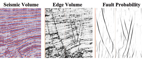
Fault surfaces are imaged primarily as discontinuities within the data. The processes in TerraSpark’s automated fault extraction workflow image the faults with sufficient resolution and signal-to-noise level to support automatic interpretation of the fault surfaces. The AFE workflow begins by creating an edge-stacked volume, which highlights edges present in the volume. Since this process also can highlight stratigraphic boundaries, an additional step is performed to define the vertically extensive fault surfaces, creating the fault probability volume. The interpreter then either automatically extracts major faults from the volume or selectively autotracks faults from the volume.
The final step in the structural workflow is horizon identification. The horizon autotracker is a 3-D waveform- based algorithm and can use embedded surfaces (faults, salt, canyons, etc.) or the fault probability volume as stopping conditions for autotracking, eliminating cycle skips and miscorrelation across faults.
Stratigraphic interpretation
The initial identification of the structural features present in a volume feeds in to the stratigraphic interpretation. All of the structural elements are used to prepare the data for TerraSpark’s Domain Transformation, where all structure is removed from the volume. In the resulting stratal volume, all structural deformation has been removed, including 3-D fault displacements, and all seismic reflections are horizontal, representing depositional surfaces.
The concept of the Domain Transformation is, at its heart, quite simple and intuitive. First, the data is mined for structural elements such as salt bodies, faults, canyons, and horizons. It is the presence of the structure in the data that has distorted and displaced the original depositional systems. These structural elements are first processed for noise removal, which improves the result of the Domain Transformation by removing cycle skips and other errant picks. Horizons are trimmed and sealed to faults and salt surfaces, closing the structural model.
Next, the structural elements are removed from the volume, producing a “stratal volume” that represents the zone of interest at the time of original deposition. If there is a visible problem with the structural interpretation at this point (for example, a mis-picked horizon or forgotten fault), it becomes immediately obvious. This allows for refinement and quality control of the structural features, further improving the interpretation.
The resultant stratal volume clearly images any depositional systems present in the volume. Channels and fan complexes that were not previously visible in the faulted and dipping seismic volume become immediately obvious and can be easily captured in the stratal volume by the same surface imaging and interpretation processes used to define salt bodies. The interpreted boundaries of these dipping channel bodies is then transformed back into the structural domain, restoring the depositional features to their proper location in the seismic amplitude volume.
Putting it all together
True volume interpretation is centered on the promise of delivering 3-D seismic visualization and interpretation, fully integrated, at every step of the interpretation workflow. It helps geoscientists work better and more efficiently by cycle-time and improving the accuracy of the final interpretation. All of the data are used to create complete 3-D surfaces that most accurately represent all of the geology represented in the 3-D seismic volume.
TerraSpark Geosciences provides these processes, tools, and workflows in Insight Earth.
 發布信息
發布信息
